Michael Valente Memorial Bridge
Appearance
40°35′44.71″N 73°39′24.02″W / 40.5957528°N 73.6566722°W
Long Beach Bridge | |
|---|---|
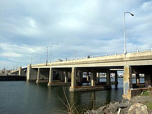
 Southwest view of the Long Beach Bridge | |
| Coordinates | 40°35′44.91″N 73°39′24.65″W / 40.5958083°N 73.6568472°W (southbound) 40°35′44.50″N 73°39′23.39″W / 40.5956944°N 73.6564972°W (northbound) |
| Carries | Motor vehicles, pedestrians |
| Crosses | Reynolds Channel |
| Locale | Nassau County, New York |
| Official name | Michael Valente Memorial Long Beach Bridge |
| Owner | Nassau County Highway Agency |
| Maintained by | Nassau County Department of Public Works |
| Heritage status | Eligible for the NRHP |
| ID number | 3300301 (southbound) 3300302 (northbound) |
| Characteristics | |
| Design | Bascule bridge |
| Material | Steel-deck |
| Total length | 820 feet (250 m) |
| Width | Each span: 45 feet (14 m) Roadway: 36 feet (11 m) |
| Longest span | 150 feet (46 m) |
| No. of spans | 2 |
| Clearance below | 30.4 feet (9.3 m) |
| No. of lanes | 6 total (3 in each direction) |
| History | |
| Construction start | August 13, 1953 |
| Construction cost | US$5,000,000 |
| Opened | May 19, 1955 (first span) July 25, 1956 (second span) |
| Statistics | |
| Daily traffic | 19654 (southbound, 1997) 19515 (northbound, 1997) |
| Location | |
 | |
| References | |
| [1][2][3] | |
The Long Beach Bridge is a drawbridge crossing Reynolds Channel, connecting Long Beach and Island Park, New York. There is no toll. The bridge starts in Long Beach as Long Beach Boulevard. At Barnum Island, the main road continues northeast as Austin Boulevard, while Long Beach Road branches to the north.
References
- ^ [1]
- ^ "Long Beach Bridge (Nassau CR 1)". Nycroads.com. Retrieved 2015-04-06.
- ^ "National Bridge Inventory Database Search - 2012". Nationalbridges.com. Retrieved 2015-04-06.
External links
