
Heinersreuth
Heinersreuth | |
|---|---|
 Town hall | |
 Coat of arms | |
Location of Heinersreuth within Bayreuth district 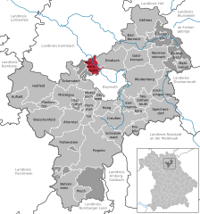 | |
 Heinersreuth  Heinersreuth | |
| Coordinates: 49°58′4.54″N 11°31′54.82″E / 49.9679278°N 11.5318944°E | |
| Country | Germany |
| State | Bavaria |
| Admin. region | Oberfranken |
| District | Bayreuth |
| Subdivisions | 18 Ortsteile |
| Government | |
| • Mayor | Simone Kirschner (CSU) |
| Area | |
| • Total | 14.63 km2 (5.65 sq mi) |
| Elevation | 340 m (1,120 ft) |
| Population (2022-12-31)[1] | |
| • Total | 3,853 |
| • Density | 260/km2 (680/sq mi) |
| Time zone | UTC+01:00 (CET) |
| • Summer (DST) | UTC+02:00 (CEST) |
| Postal codes | 95500 |
| Dialling codes | 0921 |
| Vehicle registration | BT |
| Website | www.heinersreuth.de |
Heinersreuth is a municipality in the district of Bayreuth in Bavaria in Germany.
References
- ^ Genesis Online-Datenbank des Bayerischen Landesamtes für Statistik Tabelle 12411-003r Fortschreibung des Bevölkerungsstandes: Gemeinden, Stichtag (Einwohnerzahlen auf Grundlage des Zensus 2011) (Hilfe dazu).
Wikimedia Commons has media related to Heinersreuth.
Towns and municipalities in Bayreuth (district) | ||
|---|---|---|
|  | |
| International | |
|---|---|
| National | |
This Bayreuth district location article is a stub. You can help Wikipedia by expanding it. |