Rohr, Middle Franconia
Appearance
Rohr | |
|---|---|
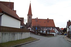
 Church of Saint Emmeram and the rectory | |
Location of Rohr within Roth district  | |
| Coordinates: 49°20′N 10°53′E / 49.333°N 10.883°E | |
| Country | Germany |
| State | Bavaria |
| Admin. region | Mittelfranken |
| District | Roth |
| Subdivisions | 17 districts |
| Government | |
| • Mayor | Felix Fröhlich (SPD) |
| Area | |
| • Total | 46.51 km2 (17.96 sq mi) |
| Elevation | 350 m (1,150 ft) |
| Population (2023-12-31)[1] | |
| • Total | 3,789 |
| • Density | 81/km2 (210/sq mi) |
| Time zone | UTC+01:00 (CET) |
| • Summer (DST) | UTC+02:00 (CEST) |
| Postal codes | 91189 |
| Dialling codes | 09876 |
| Vehicle registration | RH |
| Website | www.rohr-mfr.de |
Rohr is a municipality in the district of Roth, in Bavaria, Germany.
References
- ^ Genesis Online-Datenbank des Bayerischen Landesamtes für Statistik Tabelle 12411-003r Fortschreibung des Bevölkerungsstandes: Gemeinden, Stichtag (Einwohnerzahlen auf Grundlage des Zensus 2011).
Wikimedia Commons has media related to Rohr, Middle Franconia.


