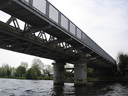
Bourne End Railway Bridge
Bourne End Railway Bridge | |
|---|---|
 Bourne End Railway Bridge showing cantilevered footbridge | |
| Coordinates | 51°34′30″N 0°42′51″W / 51.575°N 0.7142°W |
| Carries | Marlow Branch Line Thames Path |
| Crosses | River Thames |
| Locale | Bourne End, Buckinghamshire |
| Characteristics | |
| Design | Box girder and cantilever |
| Material | Iron |
| Height | 15 feet 6 inches (4.72 m)[1] |
| History | |
| Opened | 1895 |
| Location | |
 | |
Bourne End Railway Bridge is a railway bridge carrying the Marlow Branch Line, and a footpath over the River Thames in Bourne End, Buckinghamshire, England. It crosses the Thames on the reach between Cookham Lock and Marlow Lock.
The bridge was originally constructed in wood by Isambard Kingdom Brunel as part of the Wycombe Railway, opened in 1854 and operated in broad gauge until 1870.[2] The narrow spans were unpopular with river traffic and the bridge was reconstructed in steel in 1895. A footbridge, cantilevered out from the railway bridge was added in 1992, to take the Thames Path across the river;[3] this substitutes for the historical towpath crossing point at Spade Oak ferry, about 1km upstream of the bridge.[4]
In 2013, the bridge was restored and repainted in green, and a large number of rivets which had rusted away were replaced. The restoration took nearly a year to complete, being finished in December.[5] There was a plan to electrify the line, [6] but due to cost overruns during electrifying the GWR main line, this has apparently been postponed indefinitely.
See also
References
- ^ River Thames Alliance. Bridge heights on the River Thames.[permanent dead link]
- ^ B.B. Wheals (1983). Theirs were but human hearts. H.S. Publishing, Bucks. p. 113.
- ^ Cove-Smith, Chris (2006). The River Thames Book. Imray Laurie Norie and Wilson. ISBN 0-85288-892-9.
{{cite book}}: Cite has empty unknown parameter:|coauthors=(help) - ^ http://thames.me.uk/s00790.htm
- ^ "Bourne End railway bridge work 'finished by winter'". Maidenhead Advertiser. 13 August 2013. Retrieved 10 January 2014.
- ^ "Electrification for Bourne End and Marlow rail". Bucks Free Press. 21 January 2013. Retrieved 10 January 2014.
51°34′30″N 0°42′51″W / 51.57500°N 0.71417°W
