Jump to content

County of Banks, Queensland

Coordinates: 15°23′S 144°52′E / 15.383°S 144.867°E / -15.383; 144.867
From Wikipedia, the free encyclopedia

This is an old revision of this page, as edited by Kerry Raymond (talk | contribs) at 06:28, 22 August 2019 (top: Australian English tagging). The present address (URL) is a permanent link to this revision, which may differ significantly from the current revision.

Banks
Queensland
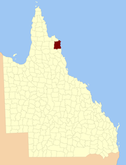
Location within Queensland
Lands administrative divisions around Banks:
Melville Melville
Mosman Banks Coral Sea
Chelmsford Dagmar Solander

The county of Banks is one of the counties of Queensland, Australia, that existed before 1901. It is located in Far North Queensland, and is named for Sir Joseph Banks, who with Captain James Cook landed in 1770 at a location within the county. Banks includes the towns of Cooktown, Lakeland and Laura.[1]

Parishes

Parish LGA Coordinates Notes
Annan Cook 15°35′S 145°15′E / 15.583°S 145.250°E / -15.583; 145.250 (Annan Parish)
Battle Camp Cook 15°22′S 144°39′E / 15.367°S 144.650°E / -15.367; 144.650 (Battle Camp Parish)
Bullhead Cook 15°50′S 144°49′E / 15.833°S 144.817°E / -15.833; 144.817 (Bullhead Parish) Lakeland
Cahir Cook 15°12′S 144°39′E / 15.200°S 144.650°E / -15.200; 144.650 (Cahir Parish)
Cook Cook 15°30′S 145°14′E / 15.500°S 145.233°E / -15.500; 145.233 (Cook Parish) Cooktown
Cowton Cook 14°59′S 144°52′E / 14.983°S 144.867°E / -14.983; 144.867 (Cowton Parish)
Deighton Cook 15°30′S 144°33′E / 15.500°S 144.550°E / -15.500; 144.550 (Deighton Parish) Laura
Discovery Hope Vale (A) 15°13′S 145°11′E / 15.217°S 145.183°E / -15.217; 145.183 (Discovery Parish)
Emla Cook 15°20′S 144°31′E / 15.333°S 144.517°E / -15.333; 144.517 (Emla Parish)
Endeavour Hope Vale (A) 15°21′S 145°15′E / 15.350°S 145.250°E / -15.350; 145.250 (Endeavour Parish)
Flattery Hope Vale (A) 14°54′S 145°11′E / 14.900°S 145.183°E / -14.900; 145.183 (Flattery Parish)
Gore Cook 15°52′S 145°04′E / 15.867°S 145.067°E / -15.867; 145.067 (Gore Parish)
Green Cook 15°32′S 144°56′E / 15.533°S 144.933°E / -15.533; 144.933 (Green Parish)
Gresley Cook 15°47′S 144°30′E / 15.783°S 144.500°E / -15.783; 144.500 (Gresley Parish)
Hann Hope Vale (A) 15°20′S 145°07′E / 15.333°S 145.117°E / -15.333; 145.117 (Hann Parish) Hope Vale
Hicks Cook 15°34′S 145°05′E / 15.567°S 145.083°E / -15.567; 145.083 (Hicks Parish)
Lythe Cook 14°57′S 144°40′E / 14.950°S 144.667°E / -14.950; 144.667 (Lythe Parish)
Macquarie Cook 15°39′S 144°34′E / 15.650°S 144.567°E / -15.650; 144.567 (Macquarie Parish)
McIvor Cook 15°07′S 145°03′E / 15.117°S 145.050°E / -15.117; 145.050 (McIvor Parish)
Melsonby Cook 15°07′S 144°51′E / 15.117°S 144.850°E / -15.117; 144.850 (Melsonby Parish)
Monkhouse Cook 15°45′S 145°17′E / 15.750°S 145.283°E / -15.750; 145.283 (Monkhouse Parish)
Munburra Cook 14°53′S 145°04′E / 14.883°S 145.067°E / -14.883; 145.067 (Munburra Parish)
Ninda Cook 15°38′S 144°46′E / 15.633°S 144.767°E / -15.633; 144.767 (Ninda Parish)
Pickersgill Cook 15°18′S 144°56′E / 15.300°S 144.933°E / -15.300; 144.933 (Pickersgill Parish)
Pryde Cook 15°10′S 145°01′E / 15.167°S 145.017°E / -15.167; 145.017 (Pryde Parish)
Ruby Cook 15°29′S 144°47′E / 15.483°S 144.783°E / -15.483; 144.783 (Ruby Parish)
Saunders Cook 15°39′S 144°54′E / 15.650°S 144.900°E / -15.650; 144.900 (Saunders Parish)
Solander Cook 15°27′S 145°06′E / 15.450°S 145.100°E / -15.450; 145.100 (Solander Parish)
Tayeto Hope Vale (A) 15°03′S 145°12′E / 15.050°S 145.200°E / -15.050; 145.200 (Tayeto Parish)
Tupia Cook 15°02′S 145°03′E / 15.033°S 145.050°E / -15.033; 145.050 (Tupia Parish)
Welbury Cook 15°06′S 144°39′E / 15.100°S 144.650°E / -15.100; 144.650 (Welbury Parish)
Yarico Cook 15°18′S 144°48′E / 15.300°S 144.800°E / -15.300; 144.800 (Yarico Parish)

References

15°23′S 144°52′E / 15.383°S 144.867°E / -15.383; 144.867