Cribin Fawr
Appearance
| Cribin Fawr | |
|---|---|
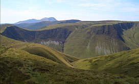
 Cribin Fawr from Maesglase, with Craig Portas to the left | |
| Highest point | |
| Elevation | 659 m (2,162 ft) |
| Prominence | 93 m (305 ft) |
| Listing | Hewitt, Nuttall, sub-HuMP |
| Coordinates | 52°43′20″N 3°47′08″W / 52.7221°N 3.7855°W |
| Naming | |
| Language of name | Welsh |
| Geography | |
 | |
| Location | Snowdonia, Wales |
| Parent range | Cadair Idris |
| OS grid | SH817150 |
| Topo map | OS Explorer OL23 |
Cribin Fawr is a mountain in Snowdonia, North Wales, situated approximately four miles to the south-west of Aran Fawddwy. It is one of the peaks in the Dyfi hills, a subgroup of the Cadair Idris group. It is a top of Maesglase, connected to its parent peak by the Craig Portas ridge. The top of Cribin Fawr is a large open plateau of peat bog. To the west is Waun-oer, to the north Cadair Idris, to the south Maesglase and Glasgwm to the east.[1]
References
- ^ Nuttall, John & Anne (1999). The Mountains of England & Wales - Volume 1: Wales (2nd edition ed.). Milnthorpe, Cumbria: Cicerone. ISBN 1-85284-304-7.
