Rogoźno
Appearance
Rogoźno | |
|---|---|
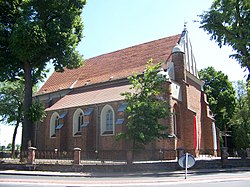
 Saint Vitus Church | |
| Coordinates: 52°44′57″N 16°59′59″E / 52.74917°N 16.99972°E | |
| Country | |
| Voivodeship | Greater Poland |
| County | Oborniki |
| Gmina | Rogoźno |
| Area | |
| • Total | 11.24 km2 (4.34 sq mi) |
| Elevation | 63 m (207 ft) |
| Population (2010) | |
| • Total | 11,337 |
| • Density | 1,000/km2 (2,600/sq mi) |
| Postal code | 64-610 |
| Website | http://www.rogozno.pl/ |
Rogoźno [rɔˈɡɔʑnɔ] (German: Rogasen) is a town in Poland, in Greater Poland Voivodeship, about 40 km north of Poznań. Its population is 11,337 (2010). It is the seat of the administrative district (gmina) called Gmina Rogoźno.
King Przemysł II of Poland was murdered in or near Rogoźno in 1296. According to one tradition he was kidnapped while staying at the town, but was so badly wounded in the process that he was unable to continue the journey, and was killed by his captors at Sierniki a few miles to the east.
Notable residents
- Rudolf Bornhof (1914–1944), Wehrmacht officer
- Marcus Jastrow (1829–1903), Talmudic scholar
External links
52°44′57″N 16°59′59″E / 52.74917°N 16.99972°E
Wikimedia Commons has media related to Rogoźno.


