
Versam-Safien railway station
Versam-Safien | |||||
|---|---|---|---|---|---|
 The station building and connecting bus. | |||||
| General information | |||||
| Location | Station 263 7104 Versam Surselva, Graubünden Switzerland | ||||
| Coordinates | 46°48′27″N 09°18′36″E / 46.80750°N 9.31000°E | ||||
| Elevation | 635 m (2,083 ft) | ||||
| Owned by | Rhaetian Railway (RhB) | ||||
| Operated by | RhB | ||||
| Line(s) | Reichenau-Tamins–Disentis/Mustér | ||||
| Distance | 32.73 km (20.34 mi) from Landquart | ||||
| History | |||||
| Opened | 1 June 1903 | ||||
| Electrified | 22 May 1922 | ||||
| |||||
| |||||


Versam-Safien is a station on the Reichenau-Tamins–Disentis/Mustér railway of the Rhaetian Railway in the Swiss canton of Graubünden. It is situated alongside the Anterior Rhine, in the railway's scenic passage through the Ruinaulta or Rhine Gorge. The station is located on the south bank of the river in the municipality of Safiental, and serves the village of Versam that lies some 3.6 km (2.2 mi) to the south and some 250 metres (820 ft) higher than the station.[1][2][3]
Services
The station is served by trains on the RE3/R31 services, which provide 1 train per hour in both directions. A postbus service meets some, but not all, trains and links the station to Versam village, and to Thalkirch and Tenna.[2][4][5]
| Preceding station | Rhätische Bahn | Following station | ||
|---|---|---|---|---|
toward Template:RhB stations | Template:RhB lines | toward Template:RhB stations |
||
| Template:RhB lines | toward Template:RhB stations |
Gallery
-
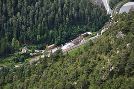 Station from above
 -
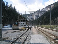 The station platforms
 -
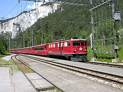 Train passing through


.jpg)
References
- ^ "1195 – Safiental" (Map). Versam-Safien (2016 ed.). 1:25 000. National Map 1:25'0000. Federal Office for Topography - swisstopo. 2014. ISBN 978-3-302-01195-0. Retrieved 2017-06-05 – via map.geo.admin.ch.
- ^ a b "Rail network". Rhaetian Railway. Archived from the original on 2017-06-05. Retrieved 2017-06-05.
- ^ "Hike along the Ruinaulta". wanderungen.ch. Archived from the original on 2017-06-05. Retrieved 2017-06-05.
- ^ "Chur–Disentis/Mustér–Andermatt" [Official Timetable of Switzerland] (PDF). Offiziellen Kursbuches der Schweiz (in German). Archived (PDF) from the original on 2017-06-06. Retrieved 2017-06-06.
- ^ "Versam Station–Versam Dorf–Thalkirch/Tenna" [Official Timetable of Switzerland] (PDF). Offiziellen Kursbuches der Schweiz (in German). Archived (PDF) from the original on 2017-06-06. Retrieved 2017-06-06.
External links
This article about a railway station in Switzerland is a stub. You can help Wikipedia by expanding it. |