
Geesteren, Gelderland
Geesteren | |
|---|---|
Dorp | |
 Coat of arms | |
| Coordinates: 52°8′20″N 6°31′35″E / 52.13889°N 6.52639°E | |
| Country | Netherlands |
| Province | Gelderland |
| Municipality | Berkelland |
| Area | |
| • Total | 19.85 km2 (7.66 sq mi) |
| Population (2007) | 1,320 |
Geesteren is a village in the eastern Dutch, located in the municipality of Berkelland, Gelderland. It was hit by a small tornado 1988, which lifted the party tent to celebrate the 1000th anniversary of Geesteren and moved it two meters.
Geesteren was a separate municipality until 1818, when it was merged with nearby Borculo.[1]
Buildings
Geesteren is well known for its church, which is one of the three churches in Europe with a stepped gable, as a result of this, the tower is topped by two weather cocks instead of just one.
The wind powered grist mill De Ster (The Star) was built in 1859.
Gallery
-
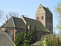 Reformed church
 -
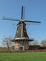 Windsmill: molen de Ster
 -
 Sculpture: de Vrouw van 't Starveld


References
- ^ Ad van der Meer and Onno Boonstra, "Repertorium van Nederlandse gemeenten", KNAW, 2006. "Archived copy". Archived from the original on February 20, 2007. Retrieved December 3, 2009.
{{cite web}}: CS1 maint: archived copy as title (link)
52°08′20″N 6°31′35″E / 52.13889°N 6.52639°E
This Gelderland location article is a stub. You can help Wikipedia by expanding it. |