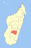
Ambalavao District
Appearance

Ambalavao District is a district[1] in central Madagascar. It covers an area of 4,798.47 km2, and had a population estimated at 209,417 in 2013.[2] It is part of Haute Matsiatra Region. Its capital is Ambalavao. The district is further divided into 17 communes:
- Ambalavao
- Ambinanindovoka
- Ambinanindroa
- Ambohimahamasina
- Ambohimandroso
- Andrainjato
- Anjoma
- Ankaramena
- Besoa
- Fenoarivo
- Iarintsena
- Kirano
- Mahazony
- Manamisoa
- Miarinarivo
- Sendrisoa
- Vohitsaoka
References
- ^ "Archived copy". Archived from the original on 2009-04-23. Retrieved 2009-05-31.
{{cite web}}: CS1 maint: archived copy as title (link) - ^ Institut National de la Statistique, Antananarivo.
21°14′00″S 47°14′00″E / 21.2333°S 47.2333°E

