Baħar iċ-Ċagħaq Redoubt
| Baħar iċ-Ċagħaq Redoubt | |
|---|---|
Ridott ta' Baħar iċ-Ċagħaq | |
| Baħar iċ-Ċagħaq, Naxxar, Malta | |
 View of Baħar iċ-Ċagħaq Redoubt from the coast | |
 Map of Baħar iċ-Ċagħaq Redoubt | |
| Coordinates | 35°56′23.5″N 14°27′20.9″E / 35.939861°N 14.455806°E |
| Type | Redoubt |
| Site information | |
| Owner | Government of Malta |
| Controlled by | Private tenant |
| Open to the public | Yes (as a bar/restaurant) |
| Condition | Intact |
| Site history | |
| Built | 1715–1716 |
| Built by | Order of Saint John |
| Materials | Limestone |
Baħar iċ-Ċagħaq Redoubt (Template:Lang-mt) is a redoubt in Baħar iċ-Ċagħaq, limits of Naxxar, Malta. It was built in 1715–1716 by the Order of Saint John as one of a series of coastal fortifications around the Maltese Islands.[1] Today, the redoubt still exists and is in relatively good condition.
It is also known as Vendôme Redoubt (Template:Lang-mt) or Madliena Redoubt (Template:Lang-mt).[2]
History
Baħar iċ-Ċagħaq Redoubt was built in 1715–1716 as part of the first building programme of redoubts in Malta. The nearest fortifications to the redoubt were Qalet Marku Battery to the northwest (now demolished) and Madliena Tower to the east. The redoubt was originally linked to the latter tower by an entrenchment, but very little remains of this have survived.[3]
The redoubt consists of a pentagonal platform with short flanks and a low parapet, with a rectangular blockhouse located at the centre of its gorge. The blockhouse is divided into two rooms, with the larger room containing the main entrance.
In World War II, a defensive position was built on the salient of the redoubt.[4]
Present day
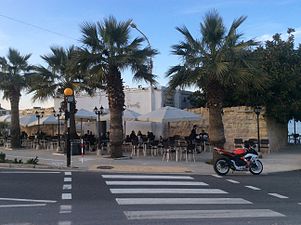
Today, the redoubt is still in relatively good condition. It is leased to a private tenant and is used as a bar and restaurant named Las Palmas.[5][6]
Gallery
-
The redoubt as viewed from the landward side. The white building is the blockhouse.
-
Interior of the redoubt
References
- ^ Zammit, Vincent (1984). "The Order's 18th Century Fortifications". Civilization. 1. Ħamrun: PEG Ltd: 170.
- ^ "Environment Protection Directorate (MEPA) Report on EIA – Environmental Impact Statement (EIS)". MEPA. July 2012. p. 21. Archived from the original on 26 June 2015.
- ^ "Madliena Entrenchment" (PDF). National Inventory of the Cultural Property of the Maltese Islands. 28 June 2013. Archived from the original (PDF) on 25 December 2015. Retrieved 22 August 2015.
- ^ "Baħar iċ-Ċagħaq Redoubt" (PDF). National Inventory of the Cultural Property of the Maltese Islands. 28 June 2013. Archived from the original (PDF) on 24 January 2016. Retrieved 22 August 2015.
- ^ Debono, James (18 June 2014). "MEPA clamps down on restaurant in 18th century fort". The Malta Independent. Retrieved 27 June 2015.
- ^ Debono, James (18 June 2014). MEPA clamps down on restaurant in 18th century fort. Malta Today. Retrieved 20 April 2016.
External links
- Redoubts in Malta
- Castles and fortifications of the Knights Hospitaller
- Military installations established in 1715
- World War II sites in Malta
- Naxxar
- Limestone buildings in Malta
- National Inventory of the Cultural Property of the Maltese Islands
- 18th-century fortifications
- 1715 establishments in Malta
- Malta stubs


