Preston Hill Country Park
Preston Hill Country Park is in Eynsford, in Kent, England. It is a woodland and former military firing range.
| Preston Hill Country Park | |
|---|---|
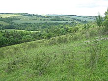
 Bench on Preston Hill | |
 | |
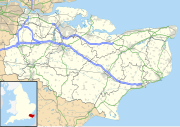
| Coordinates | 51°20′57″N 0°11′41″E / 51.3493°N 0.1948°E |
| Area | 232 acres (940,000 m2) |
| Created | 1991 |
| Operated by | Kent County Council, |
| Status | Open 7 days a week, dawn until dusk |
Within the site of the park and woodland, stood Preston Hill farmhouse. This was then damaged in 1944 after a 1000 kg parachute bomb or mine was dropped, in the early hours of 22 January 1944. Three of the farmhouse occupants were killed and 8 others were injured, later the ruined farmhouse was demolished. The site was then used as a Ministry of Defence firing range (up to the 1940s); the remnants of the range can still be seen.[1]
Since 1951 it has been a Site of Special Scientific Interest (part of 363.7 acres (1,472,000 m2) Otford To Shoreham Downs site).[2]
Preston Hill has extensive views across the countryside from the Darenth Valley (following the River Darent) to Lullingstone Country Park. The site has 232 acres (940,000 m2) of chalk grassland and woodland with many wild flowers and rare butterflies at this site of outstanding natural beauty located within the Kent Downs.[3]
On the grasslands, a variety of butterflies including chalkhill blues and dark green fritillaries can be seen. Since the site is relatively quiet, common adders and grass snakes can also be found.[4] The grassland is grazed occasionally by a herd of feral goats, which came from the Great Orme, near Colwyn Bay in North Wales.These are used to further encourage the growth of wildflowers.[5]
There are paths through the woodland (called 'Preston Plantation') at the top of the hill although they are steep in places and some have become overgrown.[4]
The park also is acreddited with a Green Flag Award by Natural England (linked with Lullingstone Country Park).[6]

How to get there
Situated along A225 Station road, cross the railway (between Shoreham and Eynsford) then head up Preston Hill. The site has no official car park, but the site is only about 1 mile from Lullingstone Country Park.
External links
References
- ^ "Explosion at Preston Hill, Shoreham (Kent), 22/1/44". sussexhistoryforum.co.uk. 17 October 2012. Retrieved 12 November 2013.
- ^ "SSSI name: Otford To Shoreham Downs" (PDF). www.sssi.naturalengland.org.uk. 1951. Retrieved 12 November 2013.
- ^ "Preston Hill". www.discoverthegardenofengland.com. Retrieved 7 November 2013.
- ^ a b "Preston Hill". kent.gov.uk. Archived from the original on 12 November 2013. Retrieved 7 November 2013.
- ^ "Preston Hill Picnic Site". www.kentdowns.org.uk. Retrieved 7 November 2013.
- ^ "Country Parks in the South East". www.naturalengland.org.uk. Natural England. 2013. Retrieved 2 December 2013.

