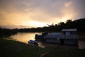
Ituí River
Appearance
| Ituí River | |
|---|---|
 | |
| Location | |
| Country | Brazil |
| State | Amazonas |
| Physical characteristics | |
| Mouth | Javary River |
| Length | 480 km (300 mi)[1] |
The Ituí River is a river of the upper Amazon Basin. It traverses some 370 km of the Atalaia do Norte municipality in the Amazonas state of north-western Brazil. It drains a very low gradient, dropping hardly 100 m over its whole extent, which results in extensive meandering. The Rio Negro, Beija-flor and Branquinho are some of its western tributaries, while the Rio Novo is its main eastern tributary. Downstream it joins the Itaquai River to form the upper Solimões.
See also
References
- ^ Ziesler, R.; Ardizzone, G.D. (1979). "Amazon River System". The Inland waters of Latin America. Food and Agriculture Organization of the United Nations. ISBN 92-5-000780-9. Archived from the original on 8 November 2014.
04°53′46″S 70°24′46″W / 4.89611°S 70.41278°W
