Katerynopil Raion
Appearance
Katerynopilskyi Raion
Катеринопільський район | |
|---|---|
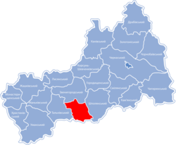
 Raion location in Cherkasy Oblast | |
| Coordinates: 48°52′4.1″N 31°4′5.8″E / 48.867806°N 31.068278°E | |
| Country | |
| Province | |
| Created | 1923 |
| Admin. center | Katerynopil |
| Area | |
| • Total | 725 km2 (280 sq mi) |
| Population (2017) | |
| • Total | 23,985 |
| • Density | 33/km2 (86/sq mi) |
| Time zone | UTC+2 (EET) |
| • Summer (DST) | UTC+3 (EEST) |
| Postal code | 20500—20545 |
| Area code | +380 4742 |
Katerynopil Raion (Ukrainian: Катеринопільський район) is a raion (district) of Cherkasy Oblast in central Ukraine. Its administrative center is located at the urban-type settlement of Katerynopil. The raion covers an area of 672.2 square kilometres (259.5 sq mi).[1] Population: 23,985 (2017 est.)[2]
People from Katerynopil Raion
- Semen Hryzlo (1887), Ukrainian military and civil activist, organizer of the Free Cossacks.[3]
- Viacheslav Chornovil, Ukrainian politician, earlier a prominent Ukrainian dissident to the Soviet policies
References
- ^ "Katerynopil raion". Cherkasy Oblast State Administration (in Ukrainian). Archived from the original on 23 March 2014. Retrieved 13 January 2012.
- ^ "Чисельність наявного населення України (Actual population of Ukraine)" (in Ukrainian). State Statistics Service of Ukraine. Retrieved 26 August 2017.
- ^ "Famous Personas - Born in Katerynopil". Who-is-Who.ua (in Ukrainian). Archived from the original on 11 March 2012. Retrieved 13 January 2012.


