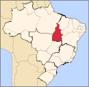
Alvorada, Tocantins
Appearance
Alvorada | |
|---|---|
 Location in Tocantins state | |
| Coordinates: 12°28′48″S 49°7′30″W / 12.48000°S 49.12500°W | |
| Country | Brazil |
| Region | North |
| State | Tocantins |
| Government | |
| • Mayor | Paulo Antônio de Lima Segundo[1] (PSD[2]) |
| Area | |
| • Total | 1,212 km2 (468 sq mi) |
| Population (2015) | |
| • Total | 8,536 |
| • Density | 7.0/km2 (18/sq mi) |
| Time zone | UTC-03:00 (BRT) |
Alvorada is a municipality located in the Brazilian state of Tocantins. Its population was 8,536 (2015) and its area is 1,212 km2 (468 sq mi).[3]
References
- ^ "Estretura Organizacional". Prefeitura de Alvorada. Retrieved 10 October 2019.
- ^ "Guia Eleições 2016". Gazeta Do Povo. Retrieved 10 October 2019.
- ^ IBGE - [1]


