
Czarnów, Lower Silesian Voivodeship
Czarnów | |
|---|---|
Village | |
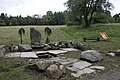
 House in Czarnów | |
 Czarnów | |
| Coordinates: 50°47′50″N 15°54′32″E / 50.79722°N 15.90889°E | |
| Country | |
| Voivodeship | Lower Silesian |
| County | Kamienna Góra |
| Gmina | Kamienna Góra |
Czarnów [ˈt͡ʂarnuf] (German: Rothenzechau) is a village in the administrative district of Gmina Kamienna Góra, within Kamienna Góra County, Lower Silesian Voivodeship, in south-western Poland.[1]
It lies approximately 11 kilometres (7 mi) west of Kamienna Góra, and 88 kilometres (55 mi) south-west of the regional capital Wrocław.
Gallery
-
 Hindu temple (2007)
 -
 Houses
 -
 Fountain

_(001)_jar.jpg)
_(002)_jar.jpg)
References
Wikimedia Commons has media related to Czarnów, Lower Silesian Voivodeship.
| Villages |  | |
|---|---|---|
| Seat (not part of the gmina) | ||
This Kamienna Góra County location article is a stub. You can help Wikipedia by expanding it. |