Zalău (river)
Appearance
| Zalău | |
|---|---|
 | |
 | |
| Location | |
| Country | Romania |
| Counties | Sălaj County |
| Villages | Zalău, Hereclean, Badon, Borla, Bocșa, Sălăjeni, Câmpia, Lompirt, Sărmășag |
| Physical characteristics | |
| Mouth | Crasna |
• location | Sărmăşag |
• coordinates | 47°20′26″N 22°48′49″E / 47.3406°N 22.8136°E |
| Length | 38 km (24 mi) |
| Basin size | 266 km2 (103 sq mi) |
| Basin features | |
| Progression | Crasna→ Tisza→ Danube→ Black Sea |
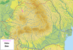
The Zalău (Template:Lang-hu) is a right tributary of the river Crasna in northwestern Romania.[1][2] It flows through the town Zalău. It discharges into the Crasna in Sărmășag. Its length is 38 km (24 mi) and its basin size is 266 km2 (103 sq mi).[2]
Hydronymy
There are several hypotheses which have been made regarding the origin of the river's name (or of the town with the same name located on the upper reach of the river):
- the name is derived from the word "silaj", meaning belt in the language spoken by the Eurasian Avars
- the name is derived from the expression "sil es agz", meaning bed of elm trees in Hungarian
- the name is a Hungarian transcription of the "Zillenmarkt", the German name of Zalău city.[3]
Tributaries
The tributaries of the Zalău are:[2]
- left: Valea Miței, Panic, Siciu, Lescuț
- right: Guruslău
References
- ^ "Planul național de management. Sinteza planurilor de management la nivel de bazine/spații hidrografice, anexa 7.1" (PDF, 5.1 MB). Administrația Națională Apele Române. 2010. p. 122.
- ^ a b c Atlasul cadastrului apelor din România. Partea 1 (in Romanian). Bucharest: Ministerul Mediului. 1992. p. 90. OCLC 895459847. River code: II.2.17
- ^ Municipiul Zalău
- Trasee turistice județul Sălaj [1]
