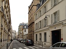
Rue Oudinot
Appearance

The Rue Oudinot is a street in the 7th arrondissement of Paris, France. It was named for Nicolas-Charles Oudinot.[1] The defunct Ministry of the French Colonial Empire was located on the street.[2]
References
- ^ Hillairet, Jacques (1963). Dictionnaire historique des rues de Paris. Paris: Éditions de minuit. p. 206. OCLC 2971232.
- ^ Thomas, Martin (2007). The French Empire Between the Wars: Imperialism, Politics and Society. Manchester, U.K.: Manchester University Press. p. 35. ISBN 9780719065187. OCLC 60564343.
