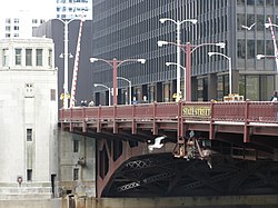
State Street Bridge (Chicago)
Appearance
This article needs additional citations for verification. (June 2018) |
State Street Bridge | |
|---|---|
 The bridge in 2008 | |
| Coordinates | 41°53′15″N 87°37′41″W / 41.88754°N 87.627994°W |
| Location | |
 | |
The Bataan-Corregidor Memorial Bridge, also known as the State Street Bridge, is a bridge that carries State Street across the Chicago River in downtown Chicago, Illinois, United States.[1]
History
The current bridge was started in 1939,[2] but material shortages in World War II caused a delay in completion until 1949.[3]
References
- ^ "Bataan-Corregidor Memorial Bridge in Chicago (State Street Bridge)". Presidential Broadcast Staff. 4 May 2015. Retrieved June 12, 2015.
- ^ "N State St Bridge, Chicago, IL (1)". chicagoloopbridges.com.
- ^ "State Street Bridge". Bridgehunter.com.
External links
 Media related to Bataan-Corregidor Memorial Bridge at Wikimedia Commons
