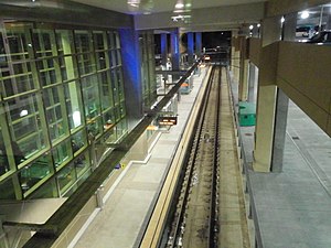
Terminal 2–Humphrey station
 Terminal 2–Humphrey in 2014 | |||||||||||
| General information | |||||||||||
| Location | 7115 Humphrey Drive | ||||||||||
| Coordinates | 44°52′27″N 93°13′27″W / 44.8742°N 93.2241°W | ||||||||||
| Owned by | Metro Transit | ||||||||||
| Line(s) | |||||||||||
| Platforms | Island platform | ||||||||||
| Tracks | 2 | ||||||||||
| Construction | |||||||||||
| Accessible | Yes | ||||||||||
| Other information | |||||||||||
| Fare zone | Airport zone: Free service to Terminal 1–Lindbergh, standard fare to other stations. | ||||||||||
| History | |||||||||||
| Opened | December 4, 2004 | ||||||||||
| Services | |||||||||||
| |||||||||||
| Future services | |||||||||||
| |||||||||||
Terminal 2–Humphrey station is a light rail station is on the Metro Blue Line. It is the fifteenth stop southbound.
This is a center-platform station and is typically accessed via a partially covered walkway from Minneapolis-Saint Paul International Airport's Humphrey Terminal. Service began at this station when the second phase of the Blue Line opened on December 4, 2004.
The southern portal to the tunnels underneath the airport is located just to the north of this station. Service between this station and Lindbergh Terminal is free to passengers and operates 24-hours a day. The Blue Line is the main mode of transportation to transfer between terminals.
The station closed on September 9, 2006, to allow for construction of a new parking garage.[citation needed] It reopened on September 8, 2007.[citation needed]
