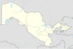
Shımbay
Appearance
Chimbay
| |
|---|---|
Town | |
| Coordinates: 42°56′N 59°47′E / 42.933°N 59.783°E | |
| Country | |
| Autonomous Republic | Karakalpakstan |
| District | Chimboy District |
| Elevation | 64 m (210 ft) |
| Population (2009) | |
• Total | 39,571 |
| Time zone | UTC+5 (UZT) |
| Area code | (+998) 6144 |
Chimbay also spelled as Chimbay (Template:Lang-uz; Template:Lang-kaa; Template:Lang-ru) is a town and seat of Chimboy District in Karakalpakstan in Uzbekistan.
Climate
Chimboy has a cool desert climate (Köppen climate classification BWk), with cold winters and hot summers. Rainfall is generally light and erratic, and occurs mainly in the winter and autumn months.
| Climate data for Chimboy (1981–2010, extremes 1937–present) | |||||||||||||
|---|---|---|---|---|---|---|---|---|---|---|---|---|---|
| Month | Jan | Feb | Mar | Apr | May | Jun | Jul | Aug | Sep | Oct | Nov | Dec | Year |
| Record high °C (°F) | 17.0 (62.6) |
27.7 (81.9) |
31.8 (89.2) |
37.1 (98.8) |
41.1 (106.0) |
43.3 (109.9) |
45.1 (113.2) |
46.0 (114.8) |
41.0 (105.8) |
33.8 (92.8) |
27.2 (81.0) |
20.0 (68.0) |
46.0 (114.8) |
| Mean daily maximum °C (°F) | 0.5 (32.9) |
3.4 (38.1) |
11.2 (52.2) |
21.6 (70.9) |
28.3 (82.9) |
33.8 (92.8) |
35.4 (95.7) |
33.6 (92.5) |
27.3 (81.1) |
19.3 (66.7) |
9.6 (49.3) |
2.7 (36.9) |
18.9 (66.0) |
| Daily mean °C (°F) | −4.4 (24.1) |
−2.5 (27.5) |
4.4 (39.9) |
14.0 (57.2) |
20.8 (69.4) |
26.2 (79.2) |
27.9 (82.2) |
25.9 (78.6) |
18.8 (65.8) |
11.0 (51.8) |
3.4 (38.1) |
−2.3 (27.9) |
11.9 (53.4) |
| Mean daily minimum °C (°F) | −8.3 (17.1) |
−7.1 (19.2) |
−1.3 (29.7) |
7.2 (45.0) |
13.5 (56.3) |
18.4 (65.1) |
20.4 (68.7) |
18.2 (64.8) |
11.2 (52.2) |
3.8 (38.8) |
−1.6 (29.1) |
−6.4 (20.5) |
5.7 (42.3) |
| Record low °C (°F) | −33.7 (−28.7) |
−29.6 (−21.3) |
−22.6 (−8.7) |
−10.4 (13.3) |
−0.5 (31.1) |
5.9 (42.6) |
8.4 (47.1) |
6.8 (44.2) |
−3.6 (25.5) |
−13.2 (8.2) |
−25.5 (−13.9) |
−29.7 (−21.5) |
−33.7 (−28.7) |
| Average precipitation mm (inches) | 12 (0.5) |
12 (0.5) |
20 (0.8) |
17 (0.7) |
21 (0.8) |
7 (0.3) |
4 (0.2) |
4 (0.2) |
5 (0.2) |
7 (0.3) |
15 (0.6) |
12 (0.5) |
133 (5.2) |
| Average rainy days | 2 | 2 | 4 | 4 | 4 | 2 | 1 | 1 | 2 | 3 | 4 | 3 | 32 |
| Average snowy days | 5 | 3 | 2 | 0.3 | 0 | 0 | 0 | 0 | 0 | 0.2 | 1 | 4 | 16 |
| Average relative humidity (%) | 75 | 71 | 63 | 52 | 48 | 44 | 44 | 47 | 50 | 57 | 68 | 73 | 58 |
| Mean monthly sunshine hours | 119 | 143 | 169 | 220 | 317 | 362 | 375 | 380 | 288 | 224 | 150 | 104 | 2,851 |
| Source 1: Pogoda.ru.net[1] | |||||||||||||
| Source 2: NOAA (sun 1961–1990)[2] | |||||||||||||
Transportation
The road south out of Chimboy connects to Halkobod and Nukus. Another road leads northeast to Qarao‘zak and Taxtako‘pir.
References
- ^ "Weather and Climate-The Climate of Chimboy" (in Russian). Weather and Climate (Погода и климат). Archived from the original on 30 November 2019. Retrieved 30 November 2019.
- ^ "Cimbaj (Chimboy) Climate Normals 1961–1990". National Oceanic and Atmospheric Administration. Retrieved 30 November 2019.


