Jump to content

Nhà Mát

Coordinates: 9°40′N 106°34′E / 9.667°N 106.567°E / 9.667; 106.567
From Wikipedia, the free encyclopedia

This is an old revision of this page, as edited by Jevansen (talk | contribs) at 03:49, 16 December 2019 (Moving from Category:Communes of Bac Lieu Province to Category:Communes of Bạc Liêu Province using Cat-a-lot). The present address (URL) is a permanent link to this revision, which may differ significantly from the current revision.

Nhà Mát
Map
Country Vietnam
ProvinceBạc Liêu
CityBạc Liêu
Time zoneUTC+07:00 (Indochina Time)

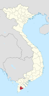
Nhà Mát is a ward (phường) of Bạc Liêu city in Bạc Liêu Province, Vietnam[1].

References

  1. ^ "Administrative subdivisions". To find information at reference, go to row 95, then row 954, and it is listed on row 31831: General Statistics Office of Vietnam.{{cite web}}: CS1 maint: location (link) CS1 maint: url-status (link)

9°40′N 106°34′E / 9.667°N 106.567°E / 9.667; 106.567