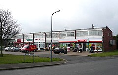
Inkersall
| Inkersall Green | |
|---|---|
 Attlee Road, Inkersall | |
Location within Derbyshire | |
| OS grid reference | SK419728 |
| District | |
| Shire county | |
| Region | |
| Country | England |
| Sovereign state | United Kingdom |
| Post town | CHESTERFIELD |
| Postcode district | S43 |
| Dialling code | 01246 |
| Police | Derbyshire |
| Fire | Derbyshire |
| Ambulance | East Midlands |
Inkersall and Inkersall Green (informally referred to by local residents as Inky[citation needed]) are areas of settlement in Derbyshire, England. They are located south of the A619 road, 4 miles (6 km) east of Chesterfield and close to Junction 29a of the M1 Motorway.
Inkersall is a hamlet just outside Staveley, which has seen fast development over the last few years. Recent developments include the creation of a small children's park along with the building of an additional convenience shop. Inkersall has two public houses, the Hop Flower and the Double Top.
The village is served by a regular bus service, allowing residents to travel to Staveley, Chesterfield and elsewhere. The Trans Pennine Trail passes alongside the village.
Education
Located on the main road through Inkersall is the Infant and Primary School, which also includes a Nursery. This school has been located here for many years, and the Infant School playground has recently been improved and now has a host of different play areas.
Pupils generally feed into Netherthorpe School or Springwell Community College, both of which are in Staveley.
History
The history of Inkersall was affected by nearby Rufford Abbey. The English Pope, Adrian IV, gave his blessing for the abbey in 1156 and following this the abbey's lands expanded and the villagers of Cratley, Rufford, Grimston and Inkersall were evicted.[1]
References
- ^ Friends of Rufford Abbey accessed 9 May 2008 accessed 9 May 2008 Archived June 22, 2007, at the Wayback Machine

