
Ennepetal
Ennepetal | |
|---|---|
 Ennepetal-Voerde in summer | |
 Coat of arms | |
Location of Ennepetal within Ennepe-Ruhr-Kreis district 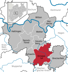 | |
 Ennepetal  Ennepetal | |
| Coordinates: 51°17′N 7°20′E / 51.283°N 7.333°E | |
| Country | Germany |
| State | North Rhine-Westphalia |
| Admin. region | Arnsberg |
| District | Ennepe-Ruhr-Kreis |
| Government | |
| • Mayor | Imke Heymann |
| Area | |
| • Total | 57.42 km2 (22.17 sq mi) |
| Highest elevation | 390 m (1,280 ft) |
| Lowest elevation | 170 m (560 ft) |
| Population (2023-12-31)[1] | |
| • Total | 30,502 |
| • Density | 530/km2 (1,400/sq mi) |
| Time zone | UTC+01:00 (CET) |
| • Summer (DST) | UTC+02:00 (CEST) |
| Postal codes | 58256 |
| Dialling codes | 02333 |
| Vehicle registration | EN |
| Website | www.ennepetal.de |
Ennepetal is a town in the district of Ennepe-Ruhr-Kreis, in North Rhine-Westphalia, Germany. It was created in 1949 out of the former municipalities Milspe and Voerde. It was named after the river Ennepe, which flows through the municipality.
The town was featured in the headlines when on April 12, 2005, a hostage taker snatched several school children from a school bus and took them as hostages, see Ennepetal hostage taking.
Division of the town
Ennepetal is divided into nine quarters (Ortsteile), which resemble former towns and villages. The population is shown as of 10 June 2015:[2]
- Altenvoerde (3663)
- Bülbringen/Oberbauer (1470)
- Büttenberg (3689)
- Hasperbach (1208)
- Königsfeld (1090)
- Milspe (9776)
- Oelkinghausen (573)
- Rüggeberg (1482)
- Voerde (7438)
International relations
 Vilvoorde, Belgium
Transport
The Ennepetal (Gevelsberg) station on the Wuppertal–Dortmund railway is served by regional trains.
The town also had a station named "Voerde" on the Kleinbahn Haspe-Voerde-Breckerfeld, which in former times was the longest streetcar in Germany. Today, the former track is being used as a walk and bicycle way, connecting the Ruhr area to the nearby Sauerland.
Notable places
The Klutert Cave is one of the largest natural caves of Germany with a length of over 5 km.
Economy
- dormakaba
- febi - Ferdinand Bilstein
- ABC - Altenloh Brinck & Co (screws)
- Dahlhaus Leuchten, GmbH
- Ernst Mager KG (screws)
Personalities
This section is empty. You can help by adding to it. (September 2017) |
Sons and daughters of the town
- Karl-Heinz Peters (1903-1990), film actor
People who are connected to Ennepetal
- Dirk Rauin (born 1957), handball player and coach
- Ralf Waldmann (born 1966), motorcycle racing driver
References
- ^ "Bevölkerung der Gemeinden Nordrhein-Westfalens am 31. Dezember 2023 – Fortschreibung des Bevölkerungsstandes auf Basis des Zensus vom 9. Mai 2011" (in German). Landesbetrieb Information und Technik NRW. Retrieved 2024-06-20.
- ^ The Quarters of Ennepetal Archived 2016-03-05 at the Wayback Machine, ennepetal.de
- ^ "Städtepartnerschaften". ennepetal.de (in German). Ennepetal. Retrieved 2019-12-11.
External links
- Official website
 (in German)
 - Kluterthöhle (in German)
Towns and municipalities in Ennepe-Ruhr | ||
|---|---|---|
 | ||
| International | |
|---|---|
| National | |
| Geographic | |
This Ennepe-Ruhr-Kreis location article is a stub. You can help Wikipedia by expanding it. |