Tumbes Province
Tumbes | |
|---|---|
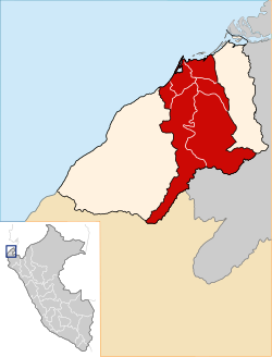
 Location of Tumbes in the Tumbes Region | |
| Country | Peru |
| Region | Tumbes |
| Capital | Tumbes |
| Government | |
| • Mayor | Carlos Jimy Silva Mena |
| Area | |
| • Total | 1,800.85 km2 (695.31 sq mi) |
| Elevation | 7 m (23 ft) |
| Population | |
| • Total | 154,962 |
| • Density | 86/km2 (220/sq mi) |
| UBIGEO | 2401 |
| Website | www |
Tumbes is a province in Peru, located in the region of the same name. It borders the Pacific Ocean on the north, the Zarumilla Province on the east, the Piura Region and Ecuador on the south and the Contralmirante Villar Province on the west. Its capital is Tumbes, which is also the regional capital.[1]
Boundaries
- North: Pacific Ocean
- East: Zarumilla Province
- South: Piura Region and Ecuador
- West: Contralmirante Villar Province
Political division
The province is divided into six districts (Spanish: distritos, singular: distrito):
References
- ^ (in Spanish) Municipalidad Provincial Tumbes, Municipalidad Provincial de Tumbes, Retrieved November 7, 2007
External links
- (in Spanish) Official province web site


