
Spenge
Spenge | |
|---|---|
 Coat of arms | |
Location of Spenge within Herford district  | |
 Spenge  Spenge | |
| Coordinates: 52°07′59″N 08°28′59″E / 52.13306°N 8.48306°E | |
| Country | Germany |
| State | North Rhine-Westphalia |
| Admin. region | Detmold |
| District | Herford |
| Subdivisions | 5 |
| Government | |
| • Mayor | Bernd Dumcke (SPD) |
| Area | |
| • Total | 40.244 km2 (15.538 sq mi) |
| Elevation | 129 m (423 ft) |
| Population (2022-12-31)[1] | |
| • Total | 14,416 |
| • Density | 360/km2 (930/sq mi) |
| Time zone | UTC+01:00 (CET) |
| • Summer (DST) | UTC+02:00 (CEST) |
| Postal codes | 32139 |
| Dialling codes | 05225 05223 (northeast), 05428 (far west), 05206 (south, esp. Nagelsholz) |
| Vehicle registration | HF |
| Website | www.spenge.de |
Spenge is a town in the district of Herford, in North Rhine-Westphalia, Germany
Geography
Spenge is situated north of Bielefeld and west of Herford. It borders Lower Saxony in the west.
Subdivisions
Spenge consists of 5 subdivisions (population as of December 31, 2001):
- Bardüttingdorf (1,480 inhabitants)
- Hücker-Aschen (1,465 inhabitants)
- Lenzinghausen (2,793 inhabitants)
- Spenge (8,696 inhabitants)
- Wallenbrück (1,976 inhabitants)
Towns and local subdistricts
|
|
|
|
|
Mayors of the town Sprenge
- 1969–1984: Karl Obermann (UWG)
- 1984–1995: Karl-Heinz Wiegelmann (SPD)
- 1995–2009: Christian Manz (born 1954), (CDU)
- 2009–today: Bernd Dumcke (SPD)
Notable places
- Lutheran Church of Sankt Martin built in the 13th Century, within the Altar of St. Martin, created around 1470.
-
 Lutheran Church of Sankt Martin in Spenge as of March 2006
 -
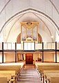 in 2005 rebuilt Wegscheider-Organ in the Church of Sankt Martin in Spenge as of March 2006


- Marienkirche in Wallenbrück built 1096, to the west of Spenge
- Mühlenburg Castle built in 1468.
-
 Gate to Schloss Mühlenburg in July 2004
 -
 Coat of arms at gate to Schloss Mühlenburg


Sons and daughters of the town
- Eberhard Werdin (1911–1991), composer and music pedagogue
- Friedrich-Wilhelm Graefe zu Baringdorf (born 1942), politician (Alliance '90 / The Greens), 1984–1987 and 1989–2009 Member of the European parliament
References
External links
Wikimedia Commons has media related to Spenge.
- Official site (in German)
Towns and municipalities in Herford (district) | ||
|---|---|---|
 | ||
| International | |
|---|---|
| National | |
| Geographic | |