Jump to content

Panheel

Coordinates: 51°11′N 5°52′E / 51.183°N 5.867°E / 51.183; 5.867
From Wikipedia, the free encyclopedia

This is an old revision of this page, as edited by Monkbot (talk | contribs) at 06:49, 30 December 2019 (top: Task 15: language icon template(s) replaced (2×);). The present address (URL) is a permanent link to this revision, which may differ significantly from the current revision.

(in Dutch) Panheel
(in Limburgish) Panhael
Village
chapel: Onze Lieve Vrouwe van 't Hartkapel
Flag of (in Dutch) Panheel (in Limburgish) Panhael
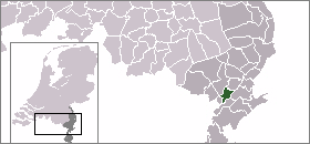
Location of (in Dutch) Panheel (in Limburgish) Panhael
CountryNetherlands Netherlands
Province Limburg
Municipality Maasgouw
Population
 (1 January 2007)
 • Total210
Time zoneUTC+1 (CET)
 • Summer (DST)UTC+2 (CEST)

Panheel is a town in the Dutch province of Limburg. It is a part of the municipality of Maasgouw, and lies about 9 km south-west of Roermond.

In 2001, Panheel had 189 inhabitants. The built-up area of the town was 0.36 km², and contained 82 residences.[1]

References

  1. ^ Statistics Netherlands (CBS), Bevolkingskernen in Nederland 2001 [1]. Statistics are for the continuous built-up area.

51°11′N 5°52′E / 51.183°N 5.867°E / 51.183; 5.867