
Hollum
Hollum | |
|---|---|
Village | |
 Hollum | |
 Location in Ameland municipality | |
 Hollum Location in the Netherlands | |
| Coordinates: 53°25′N 5°38′E / 53.417°N 5.633°E | |
| Country | |
| Province | |
| Municipality | |
| Population (2017) | |
| • Total | 1,165 |
| Time zone | UTC+1 (CET) |
| • Summer (DST) | UTC+2 (CEST) |
Hollum is the largest village on Ameland, Netherlands, one of the West Frisian Islands. It is situated on the westernmost part of the island and had, as of January 2017, a population of 1,165.[1]
Culture
Prominent in the town is a Reformed church with foundations from the 12th century and a lighthouse, which is 59 m high, dating from 1880. Another notable feature is the Commandeur huuskes. Commandeur refers to the captain of a whaling ship, as were used during the 18th century to hunt in the Arctic Ocean.
Another notable tourist attraction is the Sorgdragersmuseum, a history museum. The smock mill De Verwachting is in working order.
-
 lighthouse Bornrif
 -
 museum Sorgdrager
 -
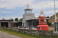 maritime museum
 -
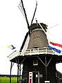 windmill De Verwachting


.jpg)
References
- ^ Kerncijfers wijken en buurten 2017 - CBS (in Dutch)
External links
![]() Media related to Hollum at Wikimedia Commons
Media related to Hollum at Wikimedia Commons
This Friesland location article is a stub. You can help Wikipedia by expanding it. |