Jump to content

Pfelderer Tal

Coordinates: 46°48′13″N 11°6′53″E / 46.80361°N 11.11472°E / 46.80361; 11.11472
From Wikipedia, the free encyclopedia

This is an old revision of this page, as edited by Monkbot (talk | contribs) at 21:31, 3 January 2020 (→‎References: Task 15: language icon template(s) replaced (1×);). The present address (URL) is a permanent link to this revision, which may differ significantly from the current revision.

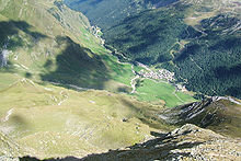
Pfelders and the Pfelderer Tal seen from the path to the Zwickauer Hütte

The Pfelderer Tal, also Pfelderstal (Italian: Val di Plan; German: Pfelderer Tal), is a side valley of the Passeier Valley in South Tyrol, Italy.

References

External links

Media related to Pfelderer Tal at Wikimedia Commons

46°48′13″N 11°6′53″E / 46.80361°N 11.11472°E / 46.80361; 11.11472