Yaritagua
Appearance
Yaritagua | |
|---|---|
City | |
| Yaritagua | |
| Coordinates: 10°4′31″N 69°7′42″W / 10.07528°N 69.12833°W | |
| Country | Venezuela |
| State | Yaracuy |
| Municipality | Peña Municipality |
| Government | |
| • Mayor | Shirley Romero (PSUV) |
| Area | |
| • Total | 510 km2 (200 sq mi) |
| Elevation | 340 m (1,120 ft) |
| Population | 120.000 |
| • Demonym | Yaritagüeño/a |
| Postal code | 3203 |
| Climate | Aw |
| Website | yaritagua.com.ve |
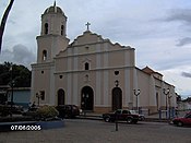
Yaritagua (Spanish pronunciation: [ʝaɾiˈtaɣwa]) is the capital of the Peña Municipality of Venezuela's state of Yaracuy. Founded in 1699 during Spain's colonization of Venezuela by Nicolas Eugenio de Ponte,[1] it retains some colonial-era buildings. The significance of sugar cane in the area has given it the nickname Ciudad Dulce de Yaracuy (Sweet City of Yaracuy). It has a population of around 120,000, and is considered Yaracuy's second city, after the capital San Felipe, Yaracuy.
The city is twinned with Zamora, Spain.[2]

References
- ^ (in Spanish) ÁNGEL OMAR MOYETINES, El Informador, Yaritagua arriba hoy a 310 años de fundada
- ^ "Ciudades y pueblos se benefician del hermanamiento con otros territorios". Larazon.es. Retrieved 11 March 2011.
External links
Wikimedia Commons has media related to Yaritagua.


