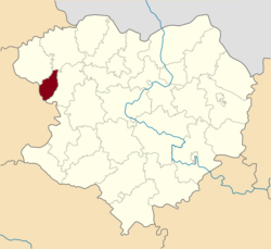
Kolomak Raion
Kolomak Raion
Коломацький район | |
|---|---|
 Raion location in Kharkiv Oblast | |
| Coordinates: 49°50′13.1778″N 35°17′55.3416″E / 49.836993833°N 35.298706000°E | |
| Country | |
| Oblast | Kharkiv Oblast |
| Admin. center | Kolomak |
| Area | |
| • Total | 330 km2 (130 sq mi) |
| Population (2017) | |
| • Total | 7,028 |
| • Density | 21/km2 (55/sq mi) |
| Time zone | UTC+2 (EET) |
| • Summer (DST) | UTC+3 (EEST) |
| Website | http://kolomakrda.gov.ua |
Kolomak Raion (Ukrainian: Коломацький район) is a raion (district) in Kharkiv Oblast of Ukraine. Its administrative center is the urban-type settlement of Kolomak. Population: 7,028 (2017 est.)[1]
In Kolomak Ivan Mazepa was elected the Hetman of Left-bank Ukraine in 1687.[2] A monument of him was unveiled in July 2017 in Kolomak.[3]
References
- ^ "Чисельність наявного населення України (Actual population of Ukraine)" (in Ukrainian). State Statistics Service of Ukraine. Retrieved 26 August 2017.
- ^ Ivan Katchanovski; Zenon E. Kohut; Bohdan Y. Nebesio; Myroslav Yurkevich (2013). "Ivan Mazepa" entry in Historical Dictionary of Ukraine. Scarecrow Press. p. 362. ISBN 9780810878471.
- ^ (in Russian) A monument to Ivan Mazepa was opened in the Kharkiv region (photo), SQ (23 July 2017)


