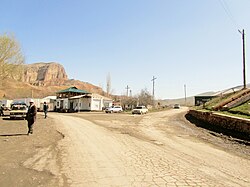
Samat, Kyrgyzstan
Appearance
Samat
Самат | |
|---|---|
Village | |
 The main traffic junction in the village of Samat | |
| Coordinates: 39°54′36.6″N 69°30′31.3″E / 39.910167°N 69.508694°E | |
| Country | |
| Region | Batken Region |
| District | Leilek District |
| Area | |
| • Total | 1.16 km2 (0.45 sq mi) |
| Population (2009)[1] | |
| • Total | 2,076 |
| • Density | 1,800/km2 (4,600/sq mi) |
| Time zone | UTC+6 |
| Website | http://www.isfana.org/ |
Samat (Kyrgyz: Самат) is a small village located in Leilek District of Batken Region, Kyrgyzstan. The village is subordinated to the town of Isfana.[2][3] According to the 2009 Population and Housing Census of Kyrgyzstan, at the time the population of Samat was 2,076.[1]
References
- ^ a b "2009 Population and Housing Census" (PDF). The National Statistical Committee of the Kyrgyz Republic (in Russian). Bishkek. 2010. Archived from the original (PDF) on 10 August 2011. Retrieved 16 May 2013.
- ^ "Isfana: City Profile". The Association of Municipalities of the Kyrgyz Republic. Archived from the original on 24 October 2014. Retrieved 24 October 2014.
- ^ "There are 45 villages in Kyrgyzstan that are part of towns". АКИpress (in Russian). 12 September 2013. Retrieved 18 March 2014.
External links
Wikimedia Commons has media related to Samat.
- Official website of the town of Isfana (in Russian)

