Huizinge
Appearance
Huizinge | |
|---|---|
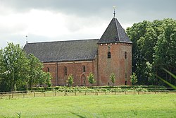
 Church of Huizinge in 2007 | |
Location in the province of Groningen in the Netherlands | |
| Coordinates: 53°21′N 6°40′E / 53.350°N 6.667°E | |
| Country | Netherlands |
| Province | Groningen |
| Municipality | Loppersum |
| Area (2012)[1] | |
• Total | 30 km2 (10 sq mi) |
| • Land | 29 km2 (11 sq mi) |
| • Water | 0 km2 (0 sq mi) |
| Population (2012)[1] | |
• Total | 100 |
| • Density | 3.3/km2 (8.6/sq mi) |
| Postal code | 9992[1] |
Huizinge (Dutch pronunciation: [ˈɦœyzɪŋə]) is a village with a population of 100 in the municipality of Loppersum in the province of Groningen in the northeast of the Netherlands.
On 16 August 2012, the heaviest induced earthquake in the Netherlands with a magnitude of 3.6 occurred with its epicenter in Huizinge.[2]
References
- ^ a b c (in Dutch) Kerncijfers wijken en buurten 2009-2012, Statistics Netherlands, 2014. Retrieved on 20 March 2015.
- ^ (in Dutch) Geïnduceerde aardbevingen in Nederland, Royal Netherlands Meteorological Institute, 2013. Retrieved on 20 March 2015.
External links
 Media related to Huizinge at Wikimedia Commons

