
Albisheim
Albisheim | |
|---|---|
 Coat of arms | |
Location of Albisheim within Donnersbergkreis district _in_KIB.svg) | |
 Albisheim  Albisheim | |
| Coordinates: 49°39′00″N 8°6′00″E / 49.65000°N 8.10000°E | |
| Country | Germany |
| State | Rhineland-Palatinate |
| District | Donnersbergkreis |
| Municipal assoc. | Göllheim |
| Government | |
| • Mayor | Ronald Zelt |
| Area | |
| • Total | 10.74 km2 (4.15 sq mi) |
| Highest elevation | 170 m (560 ft) |
| Lowest elevation | 150 m (490 ft) |
| Population (2022-12-31)[1] | |
| • Total | 1,822 |
| • Density | 170/km2 (440/sq mi) |
| Time zone | UTC+01:00 (CET) |
| • Summer (DST) | UTC+02:00 (CEST) |
| Postal codes | 67308 |
| Dialling codes | 06355 |
| Vehicle registration | KIB |
| Website | albisheim.de |


Albisheim is a municipality in the Donnersbergkreis, Rhineland-Palatinate, Germany. It is in the middle of the Zellertal.
History
In the year 835 the village is first mentioned in a document. It has been a market town for many years. Also there was a palace, but it hasn't yet been found.
Traffic
Near Albisheim there is the trunk B 47, and the village has also a railway station.
Sights
- the Protestant church from 1792,
- the historic town hall, a classicist building from 1832 and
- the 26-feet-high (8 metres) Warteturm at the wine hill. It was first mentioned 1551.
-
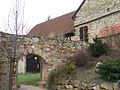 Upper melting mill
 -
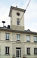 Town hall
 -
 Peter's church
 -
 The Warteturm upon the wine hill


References
- ^ "Bevölkerungsstand 2022, Kreise, Gemeinden, Verbandsgemeinden" (PDF) (in German). Statistisches Landesamt Rheinland-Pfalz. 2023.

| Authority control databases: National |
|---|