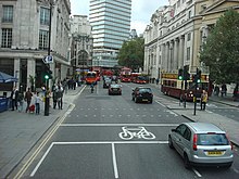
Cockspur Street
 The whole road viewed from Charles I roundabout since 1675 forming Charing Cross. At the end are the Brazilian Embassy across the junction with the Pall Mall New Zealand House. Canada House engulfing Oceanic House lines the right, north side of the street | |
| Part of | A4 |
|---|---|
| Maintained by | Transport for London |
| Length | 140 m (460 ft) |
| Location | London, United Kingdom |
| Nearest tube station | |
| Coordinates | 51°30′27″N 0°07′45″W / 51.50750°N 0.12917°W |
| Other | |
| Known for | |
Cockspur Street is a short street in the City of Westminster, London, SW1 which with a very short part of Trafalgar Square links Charing Cross – a small roundabout – to Pall Mall/Pall Mall East at the point where that road changes name, opposite the traffic exit from Haymarket. It and all the streets mentioned are part of the A4, a road running west from the City of London, and it is a minimum of three lanes wide and is two lanes one-way, one lane buses only. It has existed since at least the 16th century along a similar line.
History
A map of 1572 shows the street in existence.[1]
In 1746, John Roque's detailed map of London and ten miles around shows Cockspur Street and two very narrow passages connecting, which were later variously abolished and widened.[2][3]
After Regent Street was built heading north, Pall Mall was extended directly east. This enabled the present one-way flow around the triangle facing the north side of Cockspur Street.[3] All the small-plot properties between Cockspur Street and the newly-formed Pall Mall East were pulled down, leaving a triangular site which was taken by the College of Physicians and the Union Club. Today that side has numbers 1-5 set out below.
Properties
Number 1, Oceanic House, was originally the London office of the Oceanic Steam Navigation Company trading as the White Star Line, which operated famous liners including the RMS Titanic. "Oceanic House" is inscribed twice on the building and it forms part of Canada House.
Undivided from this are numbers 2-4, the Serious Fraud Office, and number 5 Trafalgar Square whose numbering, widely used for official purposes, comes from Cockspur Street — this is the headline[clarification needed] part of Canada House, the Canadian High Commission. Numbers 2–4 were the Canadian Military Headquarters from 1939 to 1947.[4]
Numbers 6 to 13 are no longer used, having made way for new wider street layouts. 14-16 was the Hamburg-Amerika House, London office of the Hamburg America Line. It was put up for sale in 1917 under the Trading with the Enemy Act 1914.[5]
Also proceeding east but across the street are at street level, comprehensively[clarification needed]: the Embassy of Brazil at number 14; a sightseeing/theatre tickets centre; a gift shop; a large Thai restaurant; a narrow residential building; and another restaurant — numbers 21-24. Before the end of the road is a second very broad neo-classical building marked in detailed maps with the highest numbers 25-28 — these numbers have merged into a large hotel opening onto Trafalgar Square. The entrance has flags for The Trafalgar Dining Rooms and The Rooftop restaurant. It bears address 2 Spring Gardens. Number 27 within the hotel site housed the British Coffee House (1722-1800s). In some of its final decades it was known, with the adjacent No. 26, Cockspur Street, as The British Hotel, but was demolished in 1886–7 to be replaced later by the current hotel.[6][7]
In news and literature
On 29 June 2007, a car containing explosives was found on the street. It was removed and further investigated.[8] The celebrated 'Irish Giant' Charles Byrne, who was reputedly just over 7 feet 7 inches tall (2.31m), died in 1783 at the age of 22 at his lodgings in Cockspur Street. Byrne's skeleton is preserved in the Hunterian Museum of the Royal College of Surgeons in England.
Further reading
Architecture and lost buildings
- Survey of London, vol. 16 (1935), St Martin-in-The-Fields, Pt III: Trafalgar Square and Neighbourhood. Relevant chapters are: "Site of Nos. 25-34, Cockspur Street"; "Nos. 21-24, Cockspur Street and the Two Chairmen"; "Site of Nos. 13-20, Cockspur Street"; "[Trafalgar Square] Between 66 Charing Cross [the old name for the north end of Whitehall] and the Cockspur Street entrance to Spring Gardens".
- Survey of London, vol. 20 (1940).
References
- ^ Map of 1572 by Joris Hoefnagel
- ^ 1746 map, John Roque
- ^ a b 'Pall Mall East', in Survey of London: Volume 20, St Martin-in-The-Fields, Pt III: Trafalgar Square and Neighbourhood, ed. G H Gater and F R Hiorns (London, 1940), p. 88. British History Online http://www.british-history.ac.uk/survey-london/vol20/pt3/p88 [accessed 8 May 2018].
- ^ "2–4 Cockspur Street: Canadian Military Headquarters (1939–1947)". canadahousecollection.co.uk. Retrieved 30 May 2018.
- ^ Steer, Robert. "SS Sibiria - Forgotten Wrecks of the First World War". forgottenwrecks.maritimearchaeologytrust.org. Maritime Archaeology Trust. Retrieved 2 June 2019.
- ^ 'Site of Nos. 25-34, Cockspur Street', Survey of London: Volume 16 St Martin-in-The-Fields I: Charing Cross, ed. G H Gater and E P Wheeler (London, 1935), pp. 146-149. British History Online http://www.british-history.ac.uk/survey-london/vol16/pt1/pp146-149 [accessed 8 May 2018].
- ^ Shelley, Henry C. "Part II: Coffee-houses of old London". buildinghistory. Retrieved 22 November 2015.
- ^ BBC NEWS | UK |Two car bombs found in West End


