La Aguilera
Appearance
From Wikipedia, the free encyclopedia
This is an old revision of this page, as edited by Ser Amantio di Nicolao (talk | contribs) at 05:54, 13 January 2020 (→top: add authority control). The present address (URL) is a permanent link to this revision, which may differ significantly from the current revision.
Revision as of 05:54, 13 January 2020 by Ser Amantio di Nicolao (talk | contribs) (→top: add authority control)
This article does not cite any sources. Please help improve this article by adding citations to reliable sources. Unsourced material may be challenged and removed. Find sources: "La Aguilera" – news · newspapers · books · scholar · JSTOR (June 2013) (Learn how and when to remove this message) |
Town in Castile and León, Spain
La Aguilera | |
|---|---|
town | |
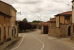
 View of La Aguilera, 2010 | |
| Country | Spain |
| Autonomous community | |
| Province | |
| Comarca | Ribera del Duero |
| Municipality | Aranda de Duero |

La Aguilera is a small Spanish village about 7 km from Aranda de Duero in the province of Burgos. Wine cellars and "merenderos" (personal BBQ areas) built into the side of a hill overlook the village. It is located in the grape-growing region of the Ribera del Duero wine region.
41°43′55″N 3°46′12″W / 41.732°N 3.770°W / 41.732; -3.770
This article about a location in the province of Burgos, Spain is a stub. You can help Wikipedia by expanding it. |
Hidden categories:
- Pages using gadget WikiMiniAtlas
- Articles lacking sources from June 2013
- All articles lacking sources
- Articles with short description
- Short description is different from Wikidata
- Pages using infobox settlement with unknown parameters
- Pages using infobox settlement with no map
- Pages using infobox settlement with no coordinates
- Coordinates on Wikidata
- All stub articles
