
Bratków, Lower Silesian Voivodeship
Bratków | |
|---|---|
Village | |
_(007).jpg) Wayside cross and a house | |
 Bratków  Bratków | |
| Coordinates: 51°00′15″N 14°56′40″E / 51.00417°N 14.94444°E | |
| Country | |
| Voivodeship | Lower Silesian |
| County | Zgorzelec |
| Gmina | Bogatynia |
Bratków [ˈbratkuf] (German: Blumberg) is a village in the administrative district of Gmina Bogatynia, within Zgorzelec County, Lower Silesian Voivodeship, in south-western Poland, close to the Czech and German borders.[1] Prior to 1945 it was in Germany.
It lies approximately 10 kilometres (6 mi) north of Bogatynia, 17 kilometres (11 mi) south of Zgorzelec, and 148 kilometres (92 mi) west of the regional capital Wrocław.
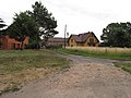
Gallery
-
 Main road
 -
 Yellow house
 -
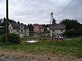 Village square
_(002).jpg)
_(008).jpg)

References
Wikimedia Commons has media related to Bratków, Lower Silesian Voivodeship.
| Town and seat |  | |
|---|---|---|
| Villages | ||
This Zgorzelec County location article is a stub. You can help Wikipedia by expanding it. |