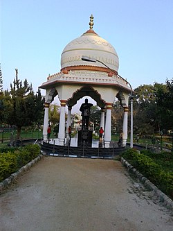
Chamarajapuram
Chamarajapura | |
|---|---|
Urban | |
 Location of Chamarajapura in Mysore | |
| Coordinates: 12°17′58″N 76°38′20″W / 12.29944°N 76.63889°W | |
| Country | India |
| State | Karnataka |
| District | Mysore District |
| City | Mysore |
| Incorporation | 1780s |
| Founded by | Chamaraja Wadiyar IX, Diwan Purnaiah |
| Named for | Maharaja Chamaraja Wadiyar IX |
| Time zone | IST |
| Zip | 570005 |
| STD | 0821 |
Chamarajapura is one of the earliest settlements and localities in Mysore, Karnataka State, India, located in the centre of Mysore city. Initially an agrahaara, parts of it were later allotted other local dwellers as well.
History
The City Planning Commission of Mysore laid out an urban city planning in as early as 1733 by Maharaja Chamarajendra Wadiyar VII, just close to the near-extinction of the Dutch East India Company, when the French Company was at its peak in South India, and the British Company had entered the South. However, the plan was realised around the 1780s by Diwan Purnaiah when working for Tipu Sultan. A monarchy of Maharaja Chamarajendra Wadiyar IX was in place during the period, after whom Chamarajapuram is named.
Constituency
Chamarajapuram falls under the Mysore Constituency in the Lok Sabha (national election) maps. In Vidhana Sabha (state election) maps, Chamarajapuram falls under Krishnaraja Constituency.
Lanes and Boulevards
Several roads and areas have been commemorative of numerous Mysore and Karnataka era celebrities.
- Bajjanna Lane, named after Bajjanna, a wealthy philanthropist working for the Palace, who funded water system in the area
- Dr Vishnuvardhan Road, named after Vishnuvardhan
- K.G.Koppal, the western half of Chamarajapuram, marked by Chamarajapuram Railway Station, adjoining locality abutting /chamarajapuram railway station is named kannegowdana koppal, named after a noted wrestler. The stretch between Jayanagar level crossing up to Oriental Research Library is known as Krishnaraja Boulevard Road, a beautiful double road with wide meridian having grown up flowering trees and foot paths on either side.
In popular culture
The cover picture of R K Laxman's Malgudi Days is a painted railway station which was inspired by Chamarajapuram Railway Station.[1][2]
Notable people
- T Chowdiah, famously known as Pitil Chowdiah, a violin and fiddle maestro in Mysore Palace
- M H Ambareesh, T Chowdiah's grandson and Kannada film actor
- M A Chandan Kumar, T Chowdiah's great-grandson, a flautist
- Vidwan T T Srinivasa Varadāchār, a dharmašhāstra āsthāna vidwan in Mysore Palace
- Vidwan T T Srinivasa Gopālāchār, T T Srinivasa Varadāchār's son, also a dharmašhāstra āsthāna vidwan
- T. P. Kailasam, popular Modern Kannada author and playwright, lived in K G Koppal for a brief period
See also
References
- ^ Rao-Kashi, Anita (18 September 2016). "Down memory lane: Walking through RK Narayan's inspiration for 'Malgudi Days'". The Economic Times. Retrieved 17 June 2017.
- ^ "Chamarajapuram railway station - it inspired the sketch by Laxman which was used in Malgudi Days - Picture of Royal Mysore Walks, Mysuru (Mysore) - TripAdvisor". www.tripadvisor.com. Retrieved 17 June 2017.
