
Bawcomville, Louisiana
Bawcomville, Louisiana | |
|---|---|
 Bawcomville, Louisiana  Bawcomville, Louisiana | |
| Coordinates: 32°28′14″N 92°10′02″W / 32.47056°N 92.16722°W | |
| Country | United States |
| State | Louisiana |
| Parish | Ouachita |
| Area | |
| • Total | 3.744 sq mi (9.70 km2) |
| • Land | 3.167 sq mi (8.20 km2) |
| • Water | 0.577 sq mi (1.49 km2) |
| Elevation | 79 ft (24 m) |
| Population | |
| • Total | 3,588 |
| • Density | 960/sq mi (370/km2) |
| Time zone | UTC-6 (Central (CST)) |
| • Summer (DST) | UTC-5 (CDT) |
| Area code | 318 |
| GNIS feature ID | 542961[2] |
Bawcomville is an unincorporated community and census-designated place in Ouachita Parish, Louisiana, United States. Its population was 3,588 as of the 2010 census.[1]
Geography
According to the U.S. Census Bureau, the community has an area of 3.744 square miles (9.70 km2); 3.167 square miles (8.20 km2) of its area is land, and 0.577 square miles (1.49 km2) is water.[1]
Prior to 2010, the Census Bureau included both Bawcomville and Brownsville in the Brownsville-Bawcomville census-designated place for statistical purposes.
References
Municipalities and communities of Ouachita Parish, Louisiana, United States | ||
|---|---|---|
| Cities | 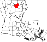 | |
| Towns | ||
| CDPs | ||
| Other unincorporated communities | ||
This Louisiana state location article is a stub. You can help Wikipedia by expanding it. |