
Raesfeld
Raesfeld | |
|---|---|
 Flag  Coat of arms | |
Location of Raesfeld within Borken district  | |
 Raesfeld  Raesfeld | |
| Coordinates: 51°46′N 6°50′E / 51.767°N 6.833°E | |
| Country | Germany |
| State | North Rhine-Westphalia |
| Admin. region | Münster |
| District | Borken |
| Subdivisions | 10 |
| Government | |
| • Mayor | Andreas Grotendorst (CDU) |
| Area | |
| • Total | 57.81 km2 (22.32 sq mi) |
| Elevation | 59 m (194 ft) |
| Population (2023-12-31)[1] | |
| • Total | 11,859 |
| • Density | 210/km2 (530/sq mi) |
| Time zone | UTC+01:00 (CET) |
| • Summer (DST) | UTC+02:00 (CEST) |
| Postal codes | 46348 |
| Dialling codes | 0 28 65 |
| Vehicle registration | BOR |
| Website | www.gemeinde-raesfeld.de |
Raesfeld (German pronunciation: [ˈʁaːsfɛlt]) is a municipality in the district of Borken in the state of North Rhine-Westphalia, Germany. It is located approximately 10 km south of Borken and 30 km east of the Dutch border. Raesfeld's landmark is the water castle at the edge of town, built in the 13th century.
Gallery
-
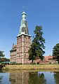 Raesfeld, tower: Schloss Raesfeld
 -
 Raesfeld, on castle: Schloss Raesfeld
 -
 Raesfeld, sculpture Kappes Anna
 -
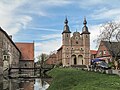
 Erle, church in the street


References
External links
- Site of the municipality (in German)
- History of the castle (in German)
- Gallery about Raesfeld in general, and the castle (in German)
- Gallery showing the Castle
Wikimedia Commons has media related to Raesfeld.
Towns and municipalities in Borken (district) | ||
|---|---|---|
 | ||
| International | |
|---|---|
| National | |
This Borken district location article is a stub. You can help Wikipedia by expanding it. |