
Baxter, Arkansas
Baxter, Arkansas | |
|---|---|
 Baxter  Baxter | |
| Coordinates: 33°31′45″N 91°29′49″W / 33.52917°N 91.49694°W | |
| Country | United States |
| State | Arkansas |
| County | Drew |
| Elevation | 121 ft (37 m) |
| Time zone | UTC-6 (Central (CST)) |
| • Summer (DST) | UTC-5 (CDT) |
| ZIP | 71638 |
| Area code | 870 |
| GNIS feature ID | 76248[1] |
Baxter is an unincorporated community in Drew County, Arkansas, United States. It is located on Arkansas Highway 35 west of Dermott, near where the highway crosses Bayou Bartholomew.[2] Located 40 mi (64 km) from the bayou mouth, it traditionally marked the head of navigation on the bayou.[3]
The Baxter Vidette, an African-American newspaper, began publishing in Baxter in 1902.[4]
References
- ^ a b "Baxter". Geographic Names Information System. United States Geological Survey, United States Department of the Interior.
- ^ Drew County, Arkansas General Highway Map (PDF) (Map). Arkansas State Highway and Transportation Department. 2018. Retrieved 2020-01-29.
- ^ Louisiana Department of Agriculture and Immigration (1885). Louisiana. Products, Resources and Attractions. p. 67. Retrieved 2020-01-29.
- ^ "About The Baxter vidette. (Baxter, Ark.) 1902-19??". Chronicling America. Library of Congress. Retrieved 2020-01-28.
Municipalities and communities of Drew County, Arkansas, United States | ||
|---|---|---|
| Cities | 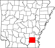 | |
| Towns | ||
| CDPs | ||
| Other unincorporated communities | ||
| Footnotes | ‡This populated place also has portions in an adjacent county or counties | |
This Arkansas state location article is a stub. You can help Wikipedia by expanding it. |