
Clothier, West Virginia
Clothier, West Virginia | |
|---|---|
 Clothier, West Virginia  Clothier, West Virginia | |
| Coordinates: 37°56′48″N 81°48′37″W / 37.94667°N 81.81028°W | |
| Country | United States |
| State | West Virginia |
| County | Boone |
| Elevation | 807 ft (246 m) |
| Time zone | UTC-5 (Eastern (EST)) |
| • Summer (DST) | UTC-4 (EDT) |
| ZIP code | 25047 |
| Area code(s) | 304 & 681 |
| GNIS feature ID | 1554157[1] |
Clothier is an unincorporated community in Logan County, West Virginia, United States. Clothier is located along West Virginia Route 17 8 miles (13 km) south of Madison. Clothier has a post office with ZIP code 25047.[2]
Clothier was named after the proprietor of a coal mine.[3]
In 1974, Jack Corn, a DOCUMERICA photographer, photographed Clothier and its inhabitants for a project on mining and its environmental and health consequences. The images are available at Wikimedia Commons.
References
- ^ "US Board on Geographic Names". United States Geological Survey. 2007-10-25. Retrieved 2008-01-31.
- ^ ZIP Code Lookup Archived 2011-06-14 at the Wayback Machine
- ^ Kenny, Hamill (1945). West Virginia Place Names: Their Origin and Meaning, Including the Nomenclature of the Streams and Mountains. Piedmont, WV: The Place Name Press. p. 177.
Gallery
-
 Clothier, West Virginia (1974)
 -
 Four young men from Clothier
 -
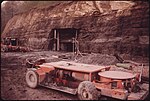 The new Robin Mine
 -
 Miner with black lung disease


Wikimedia Commons has media related to Clothier, West Virginia.

This article about a location in Logan County, West Virginia is a stub. You can help Wikipedia by expanding it. |