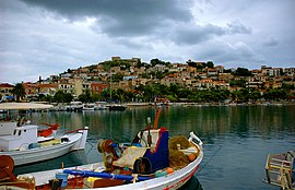
Paralio Astros
Appearance
Paralio Astros
Παράλιο Άστρος | |
|---|---|
Settlement | |
 The old part of the settlement | |
| Coordinates: 37°24′57″N 22°45′58″E / 37.415939°N 22.766151°E | |
| Country | Greece |
| Administrative region | Peloponnese |
| Regional unit | Arcadia |
| Municipality | North Kynouria |
| Elevation | 10 m (30 ft) |
| Population (2011)[2] | |
| • Community | 1,043[1] |
| Time zone | UTC+2 (EET) |
| • Summer (DST) | UTC+3 (EEST) |
| Postal code | 220 01 |
| Area code(s) | 27550 |
Paralio Astros (Greek: Παράλιο Άστρος) is a port serving the inland town of Astros, Arcadia, Greece. It is part of the municipality North Kynouria and is considered a traditional settlement. As of 2011, the port had 1,043 permanent inhabitants.
Paralio Astros possesses beaches and a harbour (renovated in 2015) which can accommodate small ships. A medieval Frankish fortress commands the heights of a peninsula called "The Island" which juts out to form the harbour. The main square is at the foot of the castle mount.
Nowadays its principal industry is tourism. It is a popular vacation spot for inhabitants of Tripoli and other parts of Greece.

See also
References
- ^ Hellenic Statistical Authority - Table. The De Jure (registered) population 2011
- ^ "Απογραφή Πληθυσμού - Κατοικιών 2011. ΜΟΝΙΜΟΣ Πληθυσμός" (in Greek). Hellenic Statistical Authority.
External links
Wikimedia Commons has media related to Paralio Astros.

