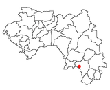
Macenta
Macenta | |
|---|---|
Sub-prefecture and town | |
| Coordinates: 8°33′N 9°28′W / 8.550°N 9.467°W | |
| Country | |
| Region | Nzérékoré Region |
| Prefecture | Macenta Prefecture |
| Population (2008 est.) | |
| • Total | 88,376 |
Geography
Macenta is the capital of the Macenta Prefecture in southeastern Guinea is located in the Guinea Highlands (at 620 metres (2,030 ft)) on the road from Nzérékoré to Guéckédou. The Nianda River joins the Makonda River near Macenta.[1]
Climate
Macenta has a tropical monsoon climate (Köppen climate classification Am).
| Climate data for Macenta | |||||||||||||
|---|---|---|---|---|---|---|---|---|---|---|---|---|---|
| Month | Jan | Feb | Mar | Apr | May | Jun | Jul | Aug | Sep | Oct | Nov | Dec | Year |
| Mean daily maximum °C (°F) | 34.0 (93.2) |
35.2 (95.4) |
34.7 (94.5) |
33.0 (91.4) |
32.7 (90.9) |
31.5 (88.7) |
30.1 (86.2) |
29.7 (85.5) |
31.0 (87.8) |
30.2 (86.4) |
31.6 (88.9) |
32.2 (90.0) |
32.2 (90.0) |
| Daily mean °C (°F) | 22.6 (72.7) |
24.6 (76.3) |
25.6 (78.1) |
25.6 (78.1) |
25.2 (77.4) |
24.4 (75.9) |
23.7 (74.7) |
23.7 (74.7) |
24.5 (76.1) |
24.4 (75.9) |
24.0 (75.2) |
22.7 (72.9) |
24.2 (75.6) |
| Mean daily minimum °C (°F) | 9.5 (49.1) |
11.4 (52.5) |
14.4 (57.9) |
17.3 (63.1) |
17.9 (64.2) |
17.6 (63.7) |
17.9 (64.2) |
18.3 (64.9) |
17.7 (63.9) |
17.2 (63.0) |
14.7 (58.5) |
10.6 (51.1) |
15.4 (59.7) |
| Average precipitation mm (inches) | 12 (0.5) |
46 (1.8) |
99 (3.9) |
188 (7.4) |
227 (8.9) |
282 (11.1) |
383 (15.1) |
535 (21.1) |
466 (18.3) |
264 (10.4) |
168 (6.6) |
41 (1.6) |
2,711 (106.7) |
| Average precipitation days (≥ 1.0 mm) | 1 | 5 | 8 | 13 | 15 | 18 | 22 | 25 | 22 | 17 | 10 | 2 | 158 |
| Average relative humidity (%) | 72 | 69 | 71 | 77 | 80 | 83 | 85 | 78 | 81 | 81 | 81 | 77 | 78 |
| Source: NOAA[2] | |||||||||||||
Recent history
French colonial and settlement influx influenced by Liberians circa 2000. It is the source of the 2014 African Ebola outbreak.[3]
Economy
Macenta is the major trading market town for tea, coffee, rice, cassava, shea butter extract, kola nuts, palm oil, and kernels grown nearby. A tea processing plant was built in Macenta in 1968, and the town has an agricultural research station, a sawmill, and several secondary schools.[4] A trade in smuggling is believed to have developed in Macenta.
The town is served by Macenta Airport.
References
- ^ Anderson, Ewan.W. (2003). International Boundaries: A Geopolitical Atlas By Ewan W. Anderson (2003). Routledge. p. 939. ISBN 1-57958-375-X. Retrieved 2008-06-16.
- ^ "Macenta Climate Normals 1961–1990". National Oceanic and Atmospheric Administration. Retrieved October 19, 2015.
- ^ http://healthmap.org/ebola/
- ^ Encyclopædia Britannica, Retrieved on June 16, 2008


