
Bartąg
Bartąg | |
|---|---|
Village | |
 | |
 Bartąg | |
| Coordinates: 53°43′N 20°28′E / 53.717°N 20.467°E | |
| Country | |
| Voivodeship | Warmian-Masurian |
| County | Olsztyn County |
| Gmina | Stawiguda |
| Population (2011[1]) | 858 |
| Time zone | UTC+1 (CET) |
| • Summer (DST) | UTC+2 (CEST) |
| Area code | +48 89 |
| Vehicle registration | NOL |
Bartąg [ˈbartɔnk] (Template:Lang-de)[2] is a village in the administrative district of Gmina Stawiguda, within Olsztyn County, Warmian-Masurian Voivodeship, in northern Poland.[3] It lies approximately 8 kilometres (5 mi) north-east of Stawiguda and 8 km (5 mi) south of the regional capital Olsztyn. It is located in Warmia.
The village has a population of 858.
Historic architecture of Bartąg includes the Saint John the Evangelist church, the rectory, several Warmian wayside shrines and two Catholic cemeteries dating back to the 19th-century.
Gallery
-
 Saint John the Evangelist church
 -
 Warmian old wayside shrine
 -
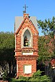 Warmian old wayside shrine
 -
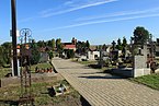 Catholic cemetery


References
- ^ "Wieś Bartąg (warmińsko-mazurskie)". Polska w liczbach (in Polish). Retrieved 4 November 2019.
- ^ "Former Territory of Germany" (in German). 2017-11-12.
- ^ "Central Statistical Office (GUS) - TERYT (National Register of Territorial Land Apportionment Journal)" (in Polish). 2008-06-01.
Wikimedia Commons has media related to Bartąg.
53°43′N 20°28′E / 53.717°N 20.467°E
| International | |
|---|---|
| National | |
This Olsztyn County location article is a stub. You can help Wikipedia by expanding it. |