
Maxville, Montana
Maxville, Montana | |
|---|---|
 Maxville  Maxville | |
| Coordinates: 46°27′53″N 113°14′03″W / 46.46472°N 113.23417°W | |
| Country | United States |
| State | Montana |
| County | Granite |
| Area | |
| • Total | 6.924 sq mi (17.93 km2) |
| • Land | 6.915 sq mi (17.91 km2) |
| • Water | 0.009 sq mi (0.02 km2) |
| Elevation | 4,839 ft (1,475 m) |
| Population | |
| • Total | 130 |
| • Density | 19/sq mi (7.2/km2) |
| Time zone | UTC-7 (Mountain (MST)) |
| • Summer (DST) | UTC-6 (MDT) |
| Area code | 406 |
| GNIS feature ID | 786949[2] |
Maxville is a census-designated place in Granite County, Montana, United States. Its population was 130 as of the 2010 census.[1] Montana Highway 1 passes through the community.
Geography
Maxville is located at 32°51′40″N 104°23′49″W / 32.861009°N 104.397071°W. According to the U.S. Census Bureau, the community has an area of 6.924 square miles (17.93 km2), of which 6.915 square miles (17.91 km2) is land and 0.009 square miles (0.023 km2) is water.[1]
References
Municipalities and communities of Granite County, Montana, United States | ||
|---|---|---|
| Towns | 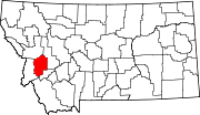 | |
| CDPs | ||
| Unincorporated communities | ||
| Ghost towns | ||
This Montana state location article is a stub. You can help Wikipedia by expanding it. |