
Rackettown, Virginia
Rackettown, Virginia | |
|---|---|
Unincorporated community | |
 Rackettown, Virginia  Rackettown, Virginia | |
| Coordinates: 36°51′48″N 80°49′44″W / 36.86333°N 80.82889°W | |
| Country | United States |
| State | Virginia |
| County | Wythe |
| Elevation | 2,155 ft (657 m) |
| Time zone | UTC-5 (Eastern (EST)) |
| • Summer (DST) | UTC-4 (EDT) |
| Area code | 276 |
| GNIS feature ID | 1472928[1] |
Rackettown is an unincorporated community in Wythe County, Virginia, United States. Rackettown is 15.3 miles (24.6 km) east-southeast of Wytheville.
References
Municipalities and communities of Wythe County, Virginia, United States | ||
|---|---|---|
| Towns | 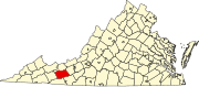 | |
| CDPs | ||
| Other communities | ||
This Wythe County, Virginia state location article is a stub. You can help Wikipedia by expanding it. |