
Ragley, Louisiana
Ragley, Louisiana | |
|---|---|
 Ragley, Louisiana  Ragley, Louisiana | |
| Coordinates: 30°30′46″N 93°13′57″W / 30.51278°N 93.23250°W | |
| Country | United States |
| State | Louisiana |
| Parish | Beauregard |
| Elevation | 92 ft (28 m) |
| Population (2014) | |
| • Total | 4,630 |
| Time zone | UTC-6 (Central (CST)) |
| • Summer (DST) | UTC-5 (CDT) |
| ZIP code | 70657 |
| Area code | 337 |
| GNIS feature ID | 555751[1] |
Ragley is an unincorporated community in Beauregard Parish, Louisiana, United States. The community is located at the junction of U.S. routes 171 and 190, 20 miles (32 km) north of Lake Charles. Ragley has a post office with ZIP code 70657.[2][3]
Ragley is predominantly populated by people of French Cajun descent.
References
- ^ "Ragley". Geographic Names Information System. United States Geological Survey, United States Department of the Interior.
- ^ United States Postal Service. "USPS - Look Up a ZIP Code". Retrieved February 19, 2015.
- ^ "Postmaster Finder - Post Offices by ZIP Code". United States Postal Service. Retrieved February 19, 2015.
Municipalities and communities of Beauregard Parish, Louisiana, United States | ||
|---|---|---|
| City | 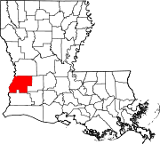 | |
| Town | ||
| CDPs | ||
| Other communities | ||
| Ghost town |
| |
| Footnotes | ‡This populated place also has portions in an adjacent parish or parishes | |
This Louisiana state location article is a stub. You can help Wikipedia by expanding it. |