Salado, Arkansas
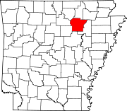
Salado is an Incorporated community in Independence County, Arkansas, United States.[1] Its elevation is 420 feet (128 m), and it is located at 35°41′28″N 91°35′44″W / 35.69111°N 91.59556°W (35.6911890, -91.5956928).[1] The Goff Petroglyph Site is located here.[2]
The spur route of Arkansas Highway 14 connects Salado with Southside.[3]
References
- ^ a b U.S. Geological Survey Geographic Names Information System: Salado, Arkansas
- ^ "National Register Information System". National Register of Historic Places. National Park Service. March 13, 2009.
- ^ Independence County, Arkansas General Highway Map (PDF) (Map). Arkansas State Highway and Transportation Department. 2004. Retrieved 2011-06-13.
External links
35°41′29″N 91°35′43″W / 35.69139°N 91.59528°W

