Kozienice Landscape Park
| Kozienice Landscape Park | |
|---|---|
| Kozienicki Park Krajobrazowy | |
IUCN category V (protected landscape/seascape) | |
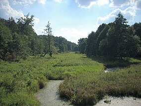
 Zagożdżonka river marshes at the Park | |
| Location | Masovian Voivodeship |
| Area | 262.33 km² |
| Established | 1983 |
Kozienice Landscape Park (Polish: Kozienicki Park Krajobrazowy) is a protected area (Landscape Park) in east-central Poland, established in 1983, covering an area of 262.33 square kilometres (101.29 sq mi).[1]
The Park lies within Masovian Voivodeship. It takes its name from the town of Kozienice.
Kozienice nature reserves
Within the Landscape Park are the 15 nature reserves of importance for wildlife, flora and fauna, including: Zagożdżon (65.67 ha), Ponty im. T. Zielińskiego (36.61 ha), Brzeźniczka (122.48 ha), Załamanek (78.97 ha), Pionki (81.60 ha), Ciszek (40.28 ha), Jedlnia (86.42 ha), Miodne (20.38 ha), Ługi Helenowskie (93.56 ha), Krępiec (278.96 ha), Ponty Dęby (50.40 ha), Leniwa (26.89 ha), Źródło Królewskie (29.67 ha), Okólny Ług (168.94 ha), and Guść (87.09 ha).[1]
References
- ^ a b Oficjalna strona Kozienickiego Parku Krajobrazowego Archived 2014-03-06 at the Wayback Machine (official webpage).
